CHCNAV X500 Professional Mapping Drone & LiDAR Packages
CHCNAV X500 Professional Mapping Drone & LiDAR Packages - None - Drone Only / No New Software - Use Existing License / 2 B10 Batteries Total + BS10 Charging Station Availability status is shown on the product page when applicable.
Delivery and Shipping
Delivery and Shipping
Your order will be carefully processed and shipped as soon as possible. A tracking number will be sent via email and/or text once the shipping label is created. For more details, please view our 60-Day Return Policy.
Speak With An Expert
Speak With An Expert
Why Choose Absolute Accuracy
Why Choose Absolute Accuracy
Since 2008, we’ve been helping pros across Los Angeles get the right gear for the job. Our team’s got your back with certified, calibrated surveying and construction equipment you can count on. We offer quick shipping, solid support, and great prices on top brands. Shop with confidence. Everything we sell is tested, reliable, and ready to perform.

CHCNAV X500 Professional Mapping Drone & LiDAR Packages
Description
Description
Datasheet
CHCNAV X500 Professional Mapping Drone
The CHCNAV X500 is a professional multirotor UAV for aerial surveying, LiDAR mapping, construction documentation, and infrastructure inspection. Its carbon-fiber airframe supports payloads up to 5 kg, with RTK positioning, visual SLAM, terrain-following flight, and forward obstacle detection to support field operations. A folding airframe and transport case make it practical to move between job sites.
Every Absolute Accuracy package includes the X500 drone, EC10 remote controller, at least two B10 intelligent flight batteries, and one BS10 intelligent battery station. We add the selected battery package and BS10 station to the manufacturer's base drone package, and include them in the displayed package price. Choose your LiDAR system, desktop software, and total battery quantity above.
Key Features
- 5 kg maximum payload: Configure the platform for a supported CHCNAV LiDAR sensor or an existing compatible payload.
- Long flight endurance: Manufacturer reference flight times reach 58 minutes without a payload, 52 minutes with a 2 kg payload, or 40 minutes with a 4 kg payload.
- RTK and visual positioning: Multi-constellation GNSS and visual SLAM support positioning and landing.
- Forward obstacle detection: A forward-facing sensor provides detection out to 80 m.
- Field-ready construction: IP55 protection and an operating temperature range of -20°C to 50°C.
- EC10 controller: A 10.1-inch, 1920 × 1200 touchscreen with up to 1,000-nit brightness and approximately five hours of controller operating time.
- SmartGo flight planning: Plan mapping routes and monitor aircraft status through CHCNAV's ground-control software.
- Dual-battery operation: Hot-swappable B10 batteries and the BS10 station simplify battery changes between flights.
Select Your LiDAR System
Choose a payload around the surfaces you need to measure, the required point density, and your deliverables. Absolute Accuracy can help match the sensor and processing workflow to your projects.
- None - Drone Only: Includes the drone platform, selected total battery quantity, and BS10 station. No LiDAR sensor or mapping camera is included. Suitable for operators who already have a compatible payload; confirm mounting, cabling, and integration requirements with us before ordering.
- AlphaAir 6 (AA6): Our recommended starting point for a new aerial LiDAR package. The AA6 combines LiDAR and integrated imaging in an approximately 1.35 kg system, with a 90° field of view, up to 2 million laser pulses per second, and up to 16 returns. It supports terrain, vegetation, corridor, and general mapping workflows. Select CoPre for point-cloud generation, or add CoProcess Pro for terrain modeling and survey deliverables.
- AlphaAir 15 (AA15) + C5 Camera: Includes the AA15 LiDAR package and a 45 MP full-frame C5 camera with a 21 mm lens for imagery and supported point-cloud colorization. The AA15 offers a 75° field of view, up to 2 million laser pulses per second, and up to 16 returns. The supplied package includes its transport container and data-transfer accessories. AA15 package P/N: 8005010114. C5 camera with 21 mm lens P/N: S39905000024202001.
- AlphaUni 20 (AU20) - No RGB Camera: A LiDAR system with a 360° field of view, up to 2 million laser pulses per second, and up to 16 returns. It supports detailed 3D data capture for terrain, infrastructure, and corridor projects. This selection includes the scanner, transport container, and supplied data-transfer accessories, with no RGB camera. For an AU20 + C5 aerial-imaging package, contact Absolute Accuracy for the camera configuration, integration requirements, and a quote. AU20 package without C5 P/N: 8005010145.
RGB colorization requires compatible imagery. The AA6 includes imaging, and the AA15 option includes its C5 camera; the AU20 option listed here does not include an RGB camera. Browse the CHCNAV product catalog for manufacturer information on these systems.
Choose Your Software
CoPre prepares the captured data. CoProcess turns the processed point cloud into survey deliverables. SmartGo flight-control software is separate from the optional desktop processing licenses below.
- No New Software - Use Existing License: Adds no new desktop software license. Select this when you already have compatible licenses or an established processing workflow.
- CoPre Standard - Perpetual: Includes one perpetual CoPre Standard license for trajectory processing, point-cloud generation, georeferencing, alignment, and colorization when supported imagery is available. Suitable when you will complete drafting or terrain analysis in existing software. P/N: 4109020543.
- CoPre Perpetual + CoProcess Pro 1-Year: Includes one perpetual CoPre Standard license plus one 12-month CoProcess Professional license. CoProcess Pro adds Classification, Vector, Volume, and Terrain modules for point-cloud editing, drafting, surface modeling, contours, and earthwork calculations. CoProcess Professional 1-year P/N: 1400070088.
- CoPre + CoProcess Pro - Both Perpetual: Includes one perpetual license for each application. Recommended for teams that prefer perpetual licenses for both processing stages. CoProcess Professional perpetual P/N: 140007008A.
The one-year term applies to CoProcess only; its bundled CoPre license is perpetual. CoProcess packages are supplied without an additional USB dongle. CoPre Airborne 3D Modeling, CoCloud, and other separately licensed modules are not included.
From Flight Plan to Deliverables
- Plan and capture: Build the mission in SmartGo, check the selected payload and battery setup, and capture the required LiDAR and imagery.
- Process: Use CoPre to process the trajectory and generate, align, and georeference the point cloud. Add RGB color where compatible imagery is available.
- Analyze and deliver: Use CoProcess Pro or your existing compatible software to classify points, create terrain surfaces and contours, draft features, and calculate volumes. Deliverables depend on the selected licenses and project workflow.
Battery Packages — BS10 Included in Every Option
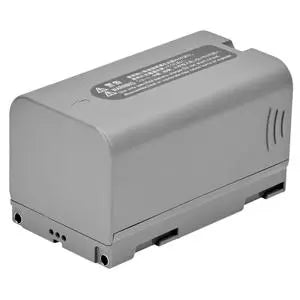
The X500 operates with two B10 intelligent flight batteries installed. The selector shows the total number of batteries supplied, including the operating pair. B10 battery P/N: 0201051284.
- 2 B10 Batteries Total + BS10 Station: One operating pair and one station.
- 4 B10 Batteries Total + BS10 Station: One operating pair, one spare pair, and one station. Recommended for regular field use.
- 6 B10 Batteries Total + BS10 Station: One operating pair, two spare pairs, and one station for repeated missions.
Each option includes one BS10 intelligent battery station (P/N: 0201051419). The station holds up to six B10 batteries and charges two simultaneously. Reference charging times are approximately 40 minutes from 20% to 90%, or 70 minutes for a full charge of two batteries, under the manufacturer's specified conditions. Additional battery pairs help you rotate packs between flights; charging requires a suitable AC power source.
Recommended Configurations
| Package | LiDAR | Software | Battery and Charging Package |
|---|---|---|---|
| Existing-Payload Platform | None | Use existing licenses | 2 B10 batteries + 1 BS10 station |
| AA6 Starter | AA6 | CoPre Standard perpetual | 2 B10 batteries + 1 BS10 station |
| AA6 Survey Package - Recommended | AA6 | CoPre perpetual + CoProcess Pro 1-year | 4 B10 batteries + 1 BS10 station |
| AA6 Extended Field Package | AA6 | CoPre + CoProcess Pro, both perpetual | 6 B10 batteries + 1 BS10 station |
The AA6 Survey Package is our recommended starting configuration for teams building a LiDAR-to-terrain workflow: it combines capture, point-cloud processing, terrain tools, and a spare battery pair.
Technical Specifications
| Aircraft type | Quadcopter with carbon-fiber structure |
|---|---|
| Maximum payload | 5 kg |
| Maximum takeoff weight | 13.9 kg |
| Aircraft weight | Approximately 4.4 kg without batteries; 8.9 kg with two batteries, with single downward gimbal |
| Unfolded dimensions | 770 × 804 × 450 mm, without propellers |
| Folded dimensions | 485 × 490 × 450 mm, with propellers |
| Maximum flight time | 58 min without payload; 52 min with 2 kg payload; 40 min with 4 kg payload |
| Maximum speed | 23 m/s |
| GNSS constellations | GPS, GLONASS, BeiDou, Galileo |
| Aircraft RTK positioning accuracy, fixed solution | Horizontal: 1 cm + 1 ppm; vertical: 1.5 cm + 1 ppm |
| RTK hovering accuracy | ±0.1 m horizontal and vertical, with moderate or no wind |
| Obstacle detection | Forward sensor; 80 m detection range |
| Protection rating | IP55 |
| Operating temperature | -20°C to 50°C (-4°F to 122°F) |
| Controller | EC10; 10.1-inch touchscreen; 1920 × 1200; up to 1,000 nits |
| B10 battery | Li-ion; 10,000 mAh at 47.04 V; 470.4 Wh; approximately 2.25 kg each |
| BS10 station | Stores six batteries; charges two at a time; accepts 100–120 VAC or 220–240 VAC, 50–60 Hz |
Flight times are manufacturer test maxima measured at approximately 10 m/s in windless conditions to battery depletion. Plan missions with appropriate battery reserves; actual endurance varies with payload, environment, and flight mode. Aircraft positioning specifications are separate from the accuracy of the selected LiDAR system and final survey deliverables.
What's Included
- 1 × CHCNAV X500 drone package; aircraft P/N: S10614504050205002
- 1 × EC10 remote controller
- 2, 4, or 6 × B10 intelligent flight batteries, according to the selected Battery Package
- 1 × BS10 intelligent battery station, included in every Battery Package
- X500 accessories kit and transport container
- 1 × pair of X500 propellers supplied with the package
- Landing pad and stakes
- Two spare antennas and international universal plug adapter
- Quick-start guide and package checklist
- Selected LiDAR package and desktop software licenses, if chosen
A GNSS base station, correction-service subscription, processing computer, and separate photogrammetry camera are not included unless specifically identified in the selected package. For an existing or third-party payload, confirm the required mounting, cabling, and supported integration before ordering.
Absolute Accuracy Support and Training
Work with Absolute Accuracy to build a practical workflow around your X500. We can help you choose the LiDAR system, camera configuration, software licenses, and battery package that fit your projects, and identify any additional equipment needed before you order.
Ask about setup assistance and training for your team. Topics can include aircraft and controller orientation, battery care and charging, SmartGo mission planning, payload setup, data handling, and the CoPre-to-CoProcess workflow. We can also help coordinate troubleshooting and manufacturer support as questions arise.
Contact us to discuss your team's experience, project requirements, and preferred training format. Training scope, scheduling, and any fees are confirmed with your quote. Call (323) 662-9237 or email info@aaisurvey.com to plan your package and onboarding.
Download the CHCNAV X500 datasheet | Explore the CHCNAV product catalog
Payment & Security
Payment methods
Your payment information is processed securely. We do not store credit card details nor have access to your credit card information.