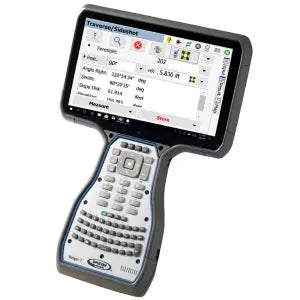
MicroSurvey FieldGenius Surveying Software | Windows
MicroSurvey FieldGenius Surveying Software | Windows - Basic with Total Station is backordered. Expect an additional 3-5 days of shipping
Couldn't load pickup availability
Delivery and Shipping
Delivery and Shipping
Your order will be shipped out within 24 hours of purchase
A UPS tracking # will be provided via email and/or text when we create the label
Why Choose Absolute Accuracy
Why Choose Absolute Accuracy
Trusted by professionals in the Los Angeles area since 2008, our expert sales team is here to support you with everything you need.
We provide certified, calibrated surveying and construction equipment designed for precision and reliability. Enjoy fast shipping, expert support, and competitive pricing on industry-leading brands. Shop with confidence, knowing you’re getting high-quality, expertly tested tools backed by our commitment to accuracy.
Speak With an Expert:
(323) 662-9237
info@aaisurvey.com
Monday - Friday 9am-5pm PST

MicroSurvey FieldGenius Surveying Software | Windows
All Equipment Will Ship Calibrated
Optical Instruments & Rotating Lasers Come With A Certification
Description
Description
Is your hardware compatible?
MicroSurvey FieldGenius is professional-grade field survey software trusted by land surveyors and engineers around the world. Compatible with leading GNSS and total station brands—including Leica, Topcon, Trimble, Stonex, GeoMax, and more—FieldGenius delivers fast, flexible, and intuitive workflows with no subscription required. Choose from three feature-packed versions: Basic, Standard, and Premium, depending on your project needs.
FieldGenius Basic with Total Station
Built for conventional surveying workflows using total stations only.
Includes:
- Total station connectivity (manual & robotic*)
- Real-time graphical linework tools
- Full COGO tools (points, lines, offsets, intersections, etc.)
- Code-free linework using Smart AutoMap™
- Staking for points and lines
- Basic instrument setup tools
*Note: Robotic total station control requires Standard or Premium for full functionality.
FieldGenius Basic with GNSS
Designed for GNSS-only workflows and RTK/PPK data collection.
Includes everything in Basic with Total Station, plus:
- GNSS receiver support (static, RTK, and PPK)
- Satellite status and signal strength monitoring
- Coordinate system and geoid model support
- RTK fix status display
- GNSS point collection and staking
FieldGenius Standard
Best for advanced surveying applications using both GNSS and total stations.
Includes everything in Basic GNSS & Total Station, plus:
- Robotic total station control
- Slope staking and surface staking
- Resection and localization workflows
- Traverse adjustment
- Road alignments and staking
- Import of design files (DXF, CSV, etc.)
FieldGenius Premium
Top-tier version for complete control of complex projects and 3D terrain work.
Includes everything in Standard, plus:
- GNSS network connectivity (NTRIP support)
- Digital terrain modeling (DTM)
- Surface creation and volume calculation
- Multi-surface handling
- Custom feature library support
- Advanced map layers and external data sources
Key Features Across All Versions:
- Smart Point AutoMap™ for automatic feature labeling
- Full 3D data visualization
- Real-time graphical feedback
- Extensive coordinate system and geoid support
- Fully customizable toolbar and interface layout
One-Time Purchase. Lifetime Access.
FieldGenius licenses are perpetual—there are no monthly fees or required subscriptions. You get full control, offline access, and complete ownership of your software.
Payment & Security
Payment methods
Your payment information is processed securely. We do not store credit card details nor have access to your credit card information.