Autel EVO II RTK Pro V3 (6k) Rugged Bundle + Software Bundle
Products by Brand
Subcategories
Leica
Leica Geosystems: Precision at Your Fingertips
For nearly 200 years, Leica Geosystems has been synonymous with unwavering accuracy and groundbreaking technology in the world of measurement and surveying. From the loftiest peaks to the deepest mines, their innovative tools empower professionals across industries to capture, analyze, and visualize the world around them with unparalleled precision.
Leica Geosystems isn't just a brand; it's a promise. A promise of confidence – knowing that your measurements are reliable, your data is accurate, and your decisions are informed. It's a promise of productivity – with efficient workflows, intuitive interfaces, and seamless connectivity, you can conquer even the most demanding projects on time and within budget. And it's a promise of innovation – Leica Geosystems pushes the boundaries of what's possible, constantly developing cutting-edge solutions that transform the way we capture and understand the world.
Their product portfolio is a testament to this unwavering commitment. Laser scanners like the BLK2GO capture intricate details of physical environments, creating immersive 3D models for everything from architectural documentation to infrastructure planning. Distance meters like the DISTO series, pocket-sized marvels of accuracy, empower quick and effortless measurements for construction, landscaping, and even DIY projects. And for those tackling complex underground challenges, Leica Geosystems offers a range of utility detection equipment to locate and map buried pipes, cables, and other unseen assets.
Beyond hardware, Leica Geosystems provides comprehensive software solutions like Infinity and CloudWorx, empowering users to process, analyze, and visualize their data with powerful tools and intuitive workflows. Whether you're a surveyor capturing vast landscapes or an engineer building the next skyscraper, Leica Geosystems offers the software to turn your data into actionable insights.
But Leica Geosystems isn't just about products. They're about people. Their global network of experts provides invaluable training and support, ensuring you get the most out of their technology. From hands-on workshops to personalized consultations, they're dedicated to your success.
In a world where every millimeter matters, Leica Geosystems stands tall. They're not just selling tools; they're selling confidence, productivity, and the power to shape the world around you with precision and certainty. So, whether you're scaling new heights or navigating hidden depths, Leica Geosystems is your partner in progress, ensuring every step you take is a step towards a more accurate, informed, and ultimately, better world.
Schonstedt
Schonstedt: Unveiling the Hidden Beneath Your Feet
For over 60 years, Schonstedt has been a leading name in unearthing the unseen. They specialize in designing and manufacturing magnetic locators, instruments that help professionals pinpoint the exact location of ferrous objects buried beneath the ground.
-
From humble beginnings to global recognition:
Founded in 1958 by engineer Elmer Schonstedt, the company started with a single product – the GA-52 Magnetic Locator. This pioneering device quickly gained recognition for its reliability and accuracy, setting the stage for Schonstedt's rise to prominence. Today, they offer a diverse range of locators catering to various industries and applications.
-
What do they do?
Schonstedt locators utilize HeliFlux dual-sensor technology to detect the magnetic fields emanating from buried iron and steel objects. These include:
- Utility pipes and cables: Ensuring safe excavation and preventing accidental damage during construction.
- Survey markers and monuments: Locating precise reference points for land surveying and mapping.
- Unexploded ordnance (UXO): Contributing to the vital task of clearing landmines and other explosives.
- Historical artifacts: Assisting archaeologists in uncovering buried treasures and ruins.
-
Products for every need:
Schonstedt's locator lineup caters to both professional and consumer users. Some of their popular models include:
- GA-52Cx: A versatile and user-friendly option for locating pipes, markers, and other common underground objects.
- Rex: A multi-frequency pipe and cable locator ideal for utility professionals.
- Maggie: A compact and portable locator perfect for DIY enthusiasts and homeowners.
-
Beyond locators:
Schonstedt's commitment extends beyond just producing locators. They offer comprehensive after-sales support, including:
- Repair services: Ensuring your locators stay in top condition for years to come.
- Training programs: Equipping users with the knowledge and skills to operate their locators effectively.
- A global network of dealers: Providing easy access to Schonstedt products and support worldwide.
-
Investing in peace of mind:
Schonstedt locators are renowned for their durability, reliability, and accuracy. They are built to withstand the toughest conditions and provide users with the confidence to tackle any underground exploration task. Whether you're a professional contractor, a passionate archaeologist, or simply a homeowner curious about what lies beneath your lawn, Schonstedt has the tools to help you safely and effectively uncover the hidden world below.
So, next time you're faced with an underground mystery, remember Schonstedt – the name synonymous with unearthing the truth, one magnetic field at a time.
There are 319 products.
Schonstedt Soft Carrying Case for MAGGIE
Padded interior to protect your MAGGIE Locator from bumps and shocks
Durable exterior to withstand the elements
Custom-fit interior to keep your locator in place
Easy-to-carry handle and shoulder strap
GeoMax Mining Transit Book - 6 Pack
Rain-resistant cover protects the book from the elements
Fine-quality ledger paper is water-proof and tear-resistant
Hard-bound cover provides a sturdy and durable construction
Left-hand pages have 4 per-inch blue horizontal lines and five red vertical lines
Right-hand pages have 10 x 10 blue lines with a red vertical center line
Book measures 4.5 x 7.25 inches for a comfortable and portable size
Komelon SelfLock Measuring Tape | 25ft In/Eng
Self-locking mechanism to keep the blade in place
Push button release for easy retraction
Inch and engineer scale markings for versatility
Nylon-coated blade for durability
25-ft blade length
Ergonomic handle for comfort
Limited lifetime manufacturer warranty
LS-B100 Laser Level Receiver
Depth Control Sensor - Fast & Easy To Use
Packed Full of Features, Accuracy Mode, Battery Life Indicator & More
Power Save/Auto Cut Off Function To Preserve Battery Life
360° Reception Angle
Battery Life Up To 80hrs
Adjustable On Grade Accuracy
IP66 Dust & Waterproof
Spectra HV302G - Green Beam SL Laser - Package
High visibility green beam is 4x more visible than standard red beam lasers allowing work at longer distances and in brighter conditions
Automatic self-leveling increases productivity with fast setups
Line scan and beam plunge feature for easy drywall layout
Rotor vial for easy and accurate vertical plumb set-up
Preset adjustable rotation speed and scan line sizes to fulfill all interior application needs
Minimizes power costs, increases reliability with choice of rechargeable or alkaline batteries
Increases flexibility with long-range radio remote control
IP66 dustproof & water resistant
More About The HV302G | All Spectra Products
Nikon N 2" Total Station (Dual Display)
Fast & Accurate EDM - 2" Accuracy
Power-Up Anywhere W/ The USB Battery Charger
Reflectorless Range Of Up To 1.968 ft
Single-Prism Range Up To 13,123 ft
Internal Memory Up To 50,000 Records
Built-In Bluetooth
IP55 Certification
Up To 22 Hrs Battery Life
More Info About The Nikon N 2" | All Nikon Products
Series IM-50 Reflectorless with Bluetooth & Laser Plummet
0I-ALW20-B Alum Heavy Duty wing screw Tripod,Black Hardware
STT402L Plus 2" Electronic Theodolite
Uses both Li-Ion rechargeable and AA battery
All purpose instrument, suitable for any kind of field work
Ergonomic keypad and backlighed LCD display
Easy to use, most of the functions with one key
IP 55 water & dust protection
Leica NA524 24x Autolevel w/ Manual
24x Magnification
Ruggedly Made To Withstand The Harshest Conditions
Minimum Focus Range Of 3.3ft
Compensator Range: ±15 Arc Minutes
Compensator Accuracy: <0.5 Arc-Second
Graduation Interval Of 1°
360 Horizontal Circle
IP56 Dust & Waterjet Resistant
Learn More About The NA524 | All Leica Products
SECO Triple Prism Bag (Jumbo)
For triple prisms and prism targets or tribrachs
Interior Dimensions: 10 x 9.5 x 3 in (25.4 x 24.1 x 7.7 cm)*
Orange
Weighs 1.06 lb (0.48 kg)
Schonstedt Soft Carrying Case for GA-52Cx, SPOT, Dunham & Morrow
Durable and water-resistant
Custom fit for Schonstedt SPOT & GA-52Cx as well as Dunham & Marrow DML2000 Series
Easy to carry and access
Protects your locator from damage
GeoMax / Leica Battery Replacement | 3400mAh | GBE211
High capacity: 3400mAh for extended usage time
Li-ion technology: Enhanced performance and long-lasting power
Consistent voltage: 7.4v for efficient power supply
Compact size: 72.00 x 39.46 x 21.15mm
Supports the GK211 Charger only
Carlson SurvCE
Enhanced Search: multiple search methods for TS/RTS in all live survey screens.
Voice Prompting: in Stakeout, so you can keep your eyes on the environment.
Map Overlays: Google, Open Street Maps, Esri® Maps, and your own WMS.
GIS Inspector: instant access to GIS attribution in the map screen.
Surface Inspector: easy comparison of plan vs. as-built elevation difference.
Obstructed Point Stakeout: guided staking of unreachable points by marking azimuth and distance.
Automatic Backsight Check: in the joystick screen, makes it easier to check your setup at any time.
All Carlson Software | Learn More About SurvCE
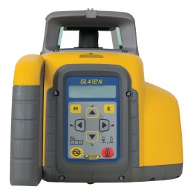
Spectra GL412N Grade Laser - Package
Range Up To 2,600ft w/ Laser Receiver
Accuracy ±1/16in At 100ft
Self-leveling Within ±5°
Single Grade From –10 to +15%
Vertical Plumb Alignment
Height of Instrument Alert
Battery Life Up To 35hrs NiMH - 50hrs Alkaline
5-Year Manufacturer Warranty Included
IP66 Dustproof & Powerful Water Jet Resistant
More About The GL412N | All Spectra Products
Nikon AS-2C Autolevel 360°
Easy To Setup & Use
34x Magnification
2.5" Resolution Power
Extremely Waterproof & Dustproof
Automatic Air-Dampened Compensator
1yr Manufacturer Warranty
X150 Laser Scanner
Strong Case: Streamlined aluminum alloy case.
Small & Light: The scanner can be easily used by a single person thanks to its small size and weight of approximately 4 kg.
Self-Calibrating: ± 5 degrees tilt supplement angle for precise leveling. A 360° one-stop scan requires only 45s.
Panoramic HDR Camera: Add color to your scan.
Wireless Control: Through the dedicated APP it is possible to control the device remotely. Scan with one click and check quality via real-time preview.
