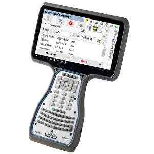
MicroSurvey FieldGenius Surveying Software | Windows
MicroSurvey FieldGenius Surveying Software | Windows - Basic with Total Station está agotado y se enviará tan pronto como vuelva a estar disponible.
No se ha podido cargar la disponibilidad de recogida
Entrega y Envío
Entrega y Envío
Todos los equipos en stock se enviarán dentro de las 24 horas posteriores a la compra.
Se proporcionará un número de seguimiento de UPS por correo electrónico o mensaje de texto cuando creemos la etiqueta.
Para equipos en espera de entrega, espere de 3 a 5 días adicionales de envío + proceso de calibración.
Igualación de precios
Igualación de precios
¿Encontró un mejor precio?
Envíenos un correo electrónico con un enlace a la lista de distribuidores autorizados y lo igualaremos o lo mejoraremos.
info@aaisurvey.com
Hable con un experto:
+1 (800) 821-9656
info@aaisurvey.com
Lunes a viernes de 9 a. m. a 5 p. m. (hora estándar del Pacífico)

MicroSurvey FieldGenius Surveying Software | Windows
Todo el equipo se enviará calibrado.
Los instrumentos ópticos y los láseres rotatorios vienen con una certificación
Descripción
Descripción
Is your hardware compatible?
MicroSurvey FieldGenius is professional-grade field survey software trusted by land surveyors and engineers around the world. Compatible with leading GNSS and total station brands—including Leica, Topcon, Trimble, Stonex, GeoMax, and more—FieldGenius delivers fast, flexible, and intuitive workflows with no subscription required. Choose from three feature-packed versions: Basic, Standard, and Premium, depending on your project needs.
FieldGenius Basic with Total Station
Built for conventional surveying workflows using total stations only.
Includes:
- Total station connectivity (manual & robotic*)
- Real-time graphical linework tools
- Full COGO tools (points, lines, offsets, intersections, etc.)
- Code-free linework using Smart AutoMap™
- Staking for points and lines
- Basic instrument setup tools
*Note: Robotic total station control requires Standard or Premium for full functionality.
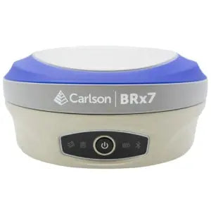
FieldGenius Basic with GNSS
Designed for GNSS-only workflows and RTK/PPK data collection.
Includes everything in Basic with Total Station, plus:
- GNSS receiver support (static, RTK, and PPK)
- Satellite status and signal strength monitoring
- Coordinate system and geoid model support
- RTK fix status display
- GNSS point collection and staking
FieldGenius Standard
Best for advanced surveying applications using both GNSS and total stations.
Includes everything in Basic GNSS & Total Station, plus:
- Robotic total station control
- Slope staking and surface staking
- Resection and localization workflows
- Traverse adjustment
- Road alignments and staking
- Import of design files (DXF, CSV, etc.)
FieldGenius Premium
Top-tier version for complete control of complex projects and 3D terrain work.
Includes everything in Standard, plus:
- GNSS network connectivity (NTRIP support)
- Digital terrain modeling (DTM)
- Surface creation and volume calculation
- Multi-surface handling
- Custom feature library support
- Advanced map layers and external data sources
Key Features Across All Versions:
- Smart Point AutoMap™ for automatic feature labeling
- Full 3D data visualization
- Real-time graphical feedback
- Extensive coordinate system and geoid support
- Fully customizable toolbar and interface layout
One-Time Purchase. Lifetime Access.
FieldGenius licenses are perpetual—there are no monthly fees or required subscriptions. You get full control, offline access, and complete ownership of your software.
Pago y seguridad
Métodos de pago
Su información de pago se procesa de forma segura. No almacenamos los datos de su tarjeta de crédito ni tenemos acceso a la información de su tarjeta de crédito.